Tien Shan
Tien Shan is a major mountain system of Central Asia, extending from the Pamirs northeast along the border between Kyrgyzstan, southeastern Kazakstan, and the Xinjiang Uygur Autonomous Region of China. It is also known as Tian Shan. The Tien Shan (Chinese, "Heavenly or celestial Mountains") has a length of about 2414 km (about 1500 mi) and a width of about 320 to 480 km (about 200 to 300 mi); it covers an area (1,036,000 sq km/400,000 sq mi) approximately equal to that of the Rocky Mountains in the United States.
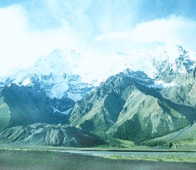
In China it divides the Junggar Pendi (Dzungarian Basin) to the north from the vast, arid Tarim Pendi (Tarim Basin) to the south. The major rivers, including the Syrdarya, Ili (Yili), and Chu, flow generally westward. In the border area where Kazakstan, Kyrgyzstan, and China meet is a string of high peaks, notably Pobedy Peak (7439 m/24,406 ft), the highest in the system, and Hantengri Feng (6995 m/22,949 ft), from which the 34-km (21-mi) long Muzart glacier descends. West of these peaks, at an altitude of 1609 m (5279 ft) is the Kyrgyz Lake Ysyk-Kul (6099 sq km/2355 sq mi). In the eastern part of the range, the most striking feature is the Turpan Pendi (Turfan Depression), a 161-km (100-mi) long stretch of lowland reaching 154 m (505 ft) below sea level and enclosed by high mountains.
The ranges are steeply sloped, their crests often incised by glaciers that wind down toward intervening valleys. The largest glaciers occur at high altitudes along the international boundary, although glaciers 19 km (12 mi) in length are not unusual in the high eastern Tien Shan.
The northern slopes of the Tien Shan receive enough moisture to support deep evergreen forests and highland meadows suitable for grazing livestock. There, at an elevation of 853 m (2800 ft), the fertile Ili Valley lies within two arms of the system. The southern slopes of the mountain system are relatively dry and barren.
The several million inhabitants of the Chinese Tien Shan are largely Muslim, non-Chinese people, farmers and herders who speak the Uygur or Kyrgyz language; colonization by ethnic Chinese, however, is on the increase. On the western side of the border, in Kyrgystan and Kazakstan the population is denser and industrialization more advanced; oil, coal, gold, and copper deposits are exploited. Livestock raising is the dominant agricultural occupation.
 Peaks
Peaks
| 1. Khan-Tengri Peak | 7 010 m |
| 2. Karakolsky Peak | 5 216 m |
| 3. B.Elzin Peak | 5 168 m |
| 4. Rossya Peak | 5 112 m |
| 5. Oguz-Bushy Peak | 5 100 m |
| 6. Jukuchak Peak | 4 600 m |
| 7. Kotur Peak | 4 400 m |
| 8. Prjevalsky Peak | 4 273 m |
| 9. Fuchika Peak | 4 100 m |
| 10. It-Tish Peak | 4 808 m |
| 11. Ala-kul Kyry Peak | 4 300 m |
| 12. Kyzyl-Su Peak | 4 590 m |
| 13. Ayu-Tor Peak | 4 382 m |
| 14. Ainur Peak | 3 900 m |
| 15. Ak-Su Peak | 4 663 m |
| 16. Mesherekova Peak | 3 420 m |
| 17. Palmira Taliaty | 3 300 m |
| 18. Orto Choku | 4 000 m |
| 19. Tulenina Peak | 4 240 m |
| 20. Students Peak | 4 202 m |
| 21. Mendeleevets Peak | 4 112 m |
| 22. Gastello Peak | 4 100 m |
| 23. GTO | 4 245 m |
| 24. Other Peaks |
|


 Kasym Kadyrov str. 55,