 Location:
 Central Asia, west of China
Geographic coordinates: 41 00 N, 75 00 E
Map references: Commonwealth of Independent States
Area:
total: 198,500 sq km
land: 191,300 sq km
water: 7,200 sq km
Area - comparative:slightly smaller than South Dakota
Land boundaries:
total: 3,878 km
Border countries: China 858 km, Kazakhstan 1,051 km, Tajikistan 870 km, Uzbekistan 1,099 km
Coastline: 0 km (landlocked)
Maritime claims: none (landlocked)
Climate: dry continental to polar in high Tien Shan; subtropical in southwest (Fergana Valley); temperate in northern foothill zone
Terrain: peaks of Tien Shan and associated valleys and basins encompass entire nation
Elevation extremes:
lowest point: Kara-Darya 132 m
highest point: Jengish Chokusu (Pik Pobedy) 7,439 m
Natural resources: abundant hydropower; significant deposits of gold and rare earth metals; locally exploitable coal, oil, and natural gas; other deposits of nepheline, mercury, bismuth, lead, and zinc
Land use:
arable land: 7%
permanent crops: 0%
permanent pastures: 44%
forests and woodland: 4%
other: 45% (1993 est.)
note: Kyrgyzstan has the world's largest natural growth walnut forest
Irrigated land: 9,000 sq km (1993 est.)
Natural hazards: NA
Kyrgyzstan, officially - Kyrgyz Republic is located in the northeastern part of Central Asia. The country's territory of 198.5 thousand square km is about the size of South Dakota. The Kyrgyz Republic borders to China, Tajikistan, Kazakhstan and Uzbekistan.
Kyrgyzstan's terrain is 94 percent mountainous, is at the juncture of two great Central Asia mountain systems - majestic Tien Shan range, extending into the Xinjiang region of northwestern China, the Kyrgyz Mountains of north Kyrgyzstan, and the Alai range in the southwest and the Pamirs. The two systems are composed of a series of mountain chains that run mainly east to west. The dominant feature is the Tien Shan (Celestial Mountains) range in the south-east. Kyrgyz republic contains the second highest peak in the former USSR, Pobeda Peak (Russian for "victory") , which has an elevation 24,406 ft (7439 m), Lenin Peak of 7134 m, Khan-Tengri Peak 7010 m.
Ninety-four percent of the country is over 1,000 m above sea level, with an average elevation of 2,750 m. Kyrygzstan is also rich in glaciers - there are more than 800 and they make more than 4 % of the country land.
More than half of the country is drained by the Naryn River and other tributaries of the Syrdarya. Numerous small and medium-sized rivers drain northern Kyrgyzstan and dissipate into the deserts and semi-deserts of southern Kazakhstan.
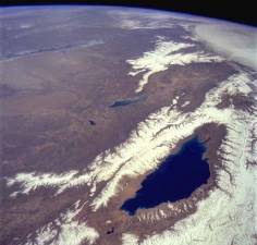
Issyk-Kul is the second-largest mountain lake in the world after Lake Titicaca. It is also the site of the country's most celebrated tourist attraction.
The Kyrgyz Republic is remarkable for its natural beauty. Magnificent mountain ranges give way to rolling syrts. Wide valleys and vast lake basins are framed by eternally snow-covered peaks, ridges and mountain ranges. The widest valleys of the Tien-Shan are offering serene walks, treks and climbs through pristine forests of juniper, sweeping meadows of medical herb, over clear mountain streams to secluded mountain lakes and to the unexplored snow-covered mountain peaks.
The location of Kyrgyzstan in the centre of Eurasia, its remoteness from the seas and oceans, and the neighboring deserts all creates extremely dry continental climate with relatively little rainfall. It averages 247 sunny days a year. In the summer in the mountains the mornings are generally fine and the afternoons hazy with occasional rain. In the lowlands the temperature ranges between -4 /-6 ░C in January to 25-30░C in July. In the highlands the temperatures range from -14 /-20░C in January to 8-12 ░C in July.
Summer is long, dry and hot. The precipitation rate in the valley districts varies from 100 mm on the western coast of the Issyk-Kul Lake, to 350-500 mm in the Chy valley.
Sometimes there are heavy snowfalls during winter. During the winter months for about 40 days the temperature remains below the freezing level. Conditions are much colder at higher elevations.
The considerable territory elation, the relief partition, high amplitudes of heights, rangers and hollows interchange pre-determined exceptional landscape variety. High-altitude landscape zone is well defined. In general, 7 high-altitude zones are singled out: low-land-flat desert, flat-foothills semi-desert with the steppe fragment, foothills-low place steppe and dry steppe, middle-mountaineering wood-meadow-steppe, alpine meadow, alpine, glacial.
Many threatening nature phenomena are common in Kyrgyzstan. One of the most destructive is an earthquake. Annually and frequently the mountains shudder, as they are "growing" up to now. Fortunately, according to the statistics, large-scale earthquakes are only once per 200 years. The scientists have measured that the growth of the mountains in some places is 6 mm per year. This figure seems to be small, but if to take millenium space of time it will be 6 meters already.
In the mountains of Kyrgyzstan there are almost 8000 glaciers. The glaciating area is 8000 sq. km. It is considerably more than the glacier area in Caucasus and Alps taken together. 580 billion m3 of fresh water is kept in the glaciers. If they are melted, water will cover all territory of the republic with a three-meter coating. There is one of the biggest alpine glaciers in the world here - the glacier South Inylchek. Its length is 59 km, ice-thickness reaches 800 m and the glaciating area is 583 km., that is equal to the area of Luxemburg. Due to the glacier heights over-fall 1,8 km., the climatic conditions along its length are very variable. The surface downwards the glacier is covered with stones and ground where the edelweiss grow. In the upper glacier part frosts can reach 30 degrees, hurricane winds blow, heavy snow falls. In Tien-Shan you can see all the classical forms of glaciating -valley, hunging etc.
The number of sunny days (there are 247 per year) in the plains of Kyrgyzstan is equal to that in Tashkent and is second to none except the southern regions of Central Asia. The relief complexity and high amplitudes of heights lead to the formation of numerous local climates. So, during a day in the mountains one can meet cool spring in the morning, feel hot summer by day, and in the evening when it snows - find himself in winter. In the mountains snow usually falls in October and doesn't melt till May. Rich snow and glacier thawing in summer courses the formation of thousand rivers and lakes.
There are about 40 thousand rivers and rivulets in Kyrgyzstan. They are characterized by big inclinations, water bearing and they aren't frozen in winter due to rapid current. Their total length is about 150 thousand km. The most abounding in water and swift river in the republic is Naryn. Only within our republic the length of this river is 535 km. This river is the beginning of Syrdaria - the second river by its size in Central Asia.
Large number of mountain rivers promoted the development of hydro-energetic. Powerful hydroelectric stations, such as Toktogul (1,2 million kWh), Kyrpsay (0.8 million kWh), Tash-Kumyr, Shamylsay and Kambartin were built. There were created artificial reservoirs. The biggest among them are Toktogul (19,5 billion cb m), Ortotokoy (470 billion cb m), Kyrov (550 billion cb m). Kyrgyzstan is also called the lake-land. About 2000 mountain lakes of different origin - tectonic, blocking, glacial and carst. Among them there are giant-lakes compared to seas and baby-lakes, which because of their small sizes aren't marked on maps.
The largest one is the Issyk-Kul lake. Sea beyond in clouds, the Tien-Shan pearl, silver mountained aquamarine Issyk-Kul is called, that in Kyrgyz means "warm lake" and if translated from old Turkic -"sacred".


 Kasym Kadyrov str. 55,